Guide To Railfanning
Chapter 1: The Moffat Tunnel Subdivision Denver to East Portal
Please note that the pictures and text on this page will display differently in different browsers, based on your own computer's settings.
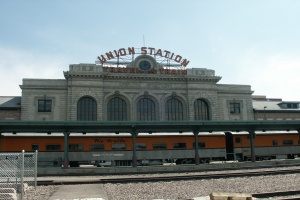
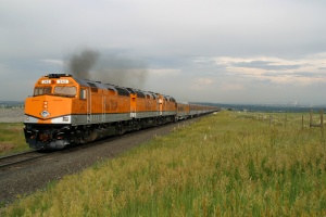
Picture 1) The Ski Train sits in front of Denver's Union Station.
So you have decided to visit Union Pacific's Moffat Tunnel Subdivision in the heart of the Rocky Mountains in Colorado? If you are looking for information on where to go to get the best pictures of trains, then look no further! The next few pages are designed to show you the best places for train watching on what used to be the Denver and Rio Grande Western mainline THROUGH the Rockies (not around them). Please note that, while history may be given from time to time through this information, it is not designed to be specifically a history page. There will be lots of information presented both in straight text and in tables, as well as pictures that should be informative to the reader.
Okay, so you have arrived in The Mile High City! Denver, Colorado! Perhaps you arrived by plane. Perhaps you arrived by car. Or, perhaps you arrived by TRAIN! If you arrived by train, then you are probably familiar with the first picture on this page (look to the left). Denver's Union Station sits at milepost zero on Union Pacific's Moffat Tunnel Subdivision. During the days of Rio Grande, the Moffat Tunnel Subdivision was simply Subdivision 1-A. In 1988, however, after the Rio Grande and Southern Pacific merged, it went from number to name, becoming the Bond Subdivision. The tracks would undergo one more subdivision change in 1999, when Union Pacific switched things around yet again, changing the Bond Subdivision into the Moffat Tunnel Subdivision.
Regardless of how you arrived in Denver, let's start this guide from a very central mark.
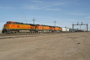
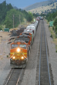
Picture 2) BNSF's MDENSTO-27 crosses over from the BNSF New North Main to the UP Main to proceed westbound on the Moffat.
The "Mouse Trap" (as it is affectionately called by Denverites) is where Interstate 70 and Interstate 25 collide together, making a mess out of the morning rush hour. I leave it up to you to find your way to this starting point! Once you are at this junction (moving at 55 MPH...the posted speed limit), make your way to westbound I-70. The very first exit west of I-70 will be Pecos Street. Exit north on Pecos as we begin our journey! Pecos will have residential neighborhoods on either side of it as you proceed north. You will pass through 52nd avenue, and then 56th avenue. After 56th, you should see a railroad crossing ahead. The grade crossing has a total of four tracks. The first is the North Yard Siding and the second is Main 3, both of which lead to Utah Junction and North Yard. The next two tracks are Mains 2 and 1, respectively, and lead over the Belt Flyover to the Belt Main Line. Tune your scanner to AAR 92 (161.490) to hear the chatter along here. You will also pick up the North Yard Tower on this frequency. Going back to the tracks, all four of these tracks are under CTC and are controlled by DS-86 in Omaha. If you continue north on Pecos, you will quickly come across yet another track. This is BNSF's Front Range Sub that connects Denver with Cheyenne, Wyoming...but that's another chapter!
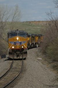
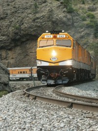
Okay, just east of Pecos on the tracks in the northernmost part of North Yard. (Please Note that this is RAILROAD property! Please do not ever trespass on railroad property. There are plenty of excellent shots to be had from public land!) Utah Junction is the point where trains such as the MNYGJ (North Yard to Grand Junction) enter the Moffat Mainline from North Yard. This is also the location where BNSF trackage rights trains enter the Moffat Mainline from BNSF tracks. Such was the case on April 27, 2003, when a westbound manifest led by three Dash 9-44CW's crossed over from the BNSF New North Main onto the Moffat Tunnel mainline (see picture 2).
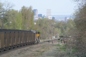
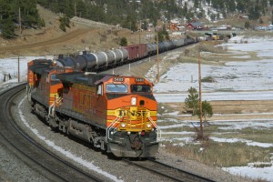
Picture 3) A UP coal load proceeds down the grade through Arvada at 72nd Avenue as the Denver Skyline protrudes up in the background.
As the tracks move west out of Denver, they enter the residential town of Arvada. If you are planning on chasing a train west, I do not suggest trying to start at Utah Junction! Trains move through Arvada at speed of 40 MPH to 50 MPH, while cars don't usually get above 30 MPH
Picture 4) A coal empty on its way to the Energy coal mine near Craig, CO crosses the east switch at the siding of Leyden.
(except on some of the larger street, where it is 45 MPH). Regardless, you are subject to traffic and stop lights. Arvada, however, is a very nice community. If you do want to do some shooting in Arvada
(Search Photo Gallery),
there are four grade crossing in particular that are nice: Kipling, 72nd, Simms, and 80th. I will get you to 80th...the other three will be up to you to figure out! If you are still sitting at Utah Junction while reading this, start your engine back up and proceed north on Pecos to I-76. Take I-76 westbound until you collide with I-70...I-76 will disappear here (as the purpose of this highway is to connect I-70 with I-80). Continue west on I-70 until you get to the Ward Street exit. You will want to be going north on Ward, which is also Colorado State Highway 72. Proceed north on Ward until you get to 64th Avenue (Ralston Road). On your journey north on Ward, you will cross one set of tracks...this is the BNSF spur that runs out to the Coors Brewing Company in Golden, CO!
Once you get to 64th Avenue, turn left (west). You will stay on 64th Avenue for a few miles (five stoplights,
Picture 5) A special run of the Summer Ski Train passes the area known as Chemical.
actually) until you get to Indiana Street (this will be the fifth stoplight). Turn right (north) onto Indiana. You will be staying on Indiana for 16 blocks...until you get to 80th Avenue! Once you reach 80th Avenue, you will notice a bridge that says "Rio Grande" on it straight ahead, crossing over Indiana. Stay calm, as that is later in this chapter! For now, turn right on 80th (east). You will soon pass Ralston Valley High School on your left. You will also pass through a four way stop at Alkire. After Alkire, you will come up to the 80th grade crossing! This is also just a few hundred feet away from the first siding west of Denver, the siding of Leyden
(Search Siding Gallery).
Now that Union Pacific has switched from DigiCon to CAD (Computer Aided Dispatcher) as their dispatching software of choice, the east end of Leyden
(Search Photo Gallery)
is now referred to as Control Point (CP) DS 012 and the west end is referred to as CP DS 013. If you find your way to 82nd Avenue (north of Leyden and geographically higher) has a nice shot of the east end of Leyden and, from the proper angle, you can get the Denver skyline in the background. Leyden used to see coal trains regularly tied down on it but, as the result of people complaining about the noise and fumes, Union Pacific uses Leyden for storage less frequently these days.
Picture 6) A westbound manifest headed for Grand Junction (the MNYGJ-20) is nearing the west end of Barbara Gulch. It will emerge after passing under Highway 93, and enter the siding of Rocky.
Okay, now, hop back in your car and proceed west on 80th Avenue back the way you came to get here. When you reach Indiana Avenue, take a right (northward) and head toward the bridge where the tracks pass over the highway. If you pull over onto the shoulder (making sure that you do not impede other traffic on Indiana), you have a very nice morning shot of an eastbound crossing over the bridge toward Leyden.
Once you are satisfied with your pictures of Leyden, it is time to head west! Now, a new intersection has been put in where Highway 72 and Indiana Avenue diverge from one another. If you were last here before 2004, you might remember that Indiana Avenue continued north and Highway 72 curves off to the west. Now, however, due to a new housing development, 86th Avenue has connected with Highway 72 at a new (typical) intersection. If you pass underneath the bridge at west Leyden northbound, you will hit this new intersection. Turn left on Highway 72 and proceed west parallel to the tracks. Initially, the tracks will be several hundred feet south of you, but you and the track will converge at the point known as Chemical
(Search Photo Gallery).
Chemical is named as such because of an oil plant (Mesa Oil) that is located on the mainline and has been served by the railroad for many years. Picture 5 shows the Ski Train as it is on the approach to the block signal at Chemical.
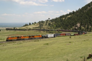
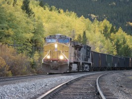
Picture 7) The westbound MDENSTO-16 winds through the curves at the base of Blue Mountain.
Once you are done taking pictures at Chemical, continue west along Highway 72. The tracks are going to disappear into a gulch (Barbara Gulch) and the road is going to travel on the top of the Mesa. Just before you reach Highway 93, you will cross over some tracks. The grade crossing is controlled by a stoplight. This is the Rocky Flats Industrial Lead and not the mainline itself. The spur leaves the mainline at the siding of Rocky
(Search Siding Gallery).
Once you hit Highway 93, you are going to make a left (south) turn and continue about a half a mile. You will pass over the Rocky Flats spur for a second time and very shortly after pass over the tracks. This marks the west end of Barbara Gulch and the east end of Rocky
(Search Photo Gallery).
If you pull over to the side of the road, you can walk along the shoulder on the bridge to take pictures of trains in either direction. Unfortunately, Rocky (as well as the next siding of Clay
(Search Siding Gallery))
are both rather inaccessible...
However, do not let that discourage you. Hop back in your car and head north on Highway 93 back toward Highway 72. Turn left (west) on Highway 72 and proceed toward Pinecliff and Rollinsville, which you get to via Coal Creek Canyon. Prior to entering the mountains, you are going to see two turnoffs. The first will be a right turnoff that goes towards Plain. The second will be a left turnoff that goes towards Blue Mountain. For now, pass Plain and head toward Blue Mountain. As you follow Blue Mountain road, you will cross the tracks at a grade crossing.
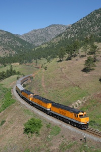
Picture 8) The Ski Train is about to enter tunnel one on a beautiful summer morning, June 28, 2003.
Before stopping here, drive up past the tracks into the mountains. You will feel like you are leaving the railroad behind, but it is for a good reason! At the top of Blue Mountain road, you will make an abrupt left turn...if you continue straight, you will fly off the road, over the end of the mountain and wind up on the tracks at the siding of Clay! You can stop along the road (there are a few pull offs on the uphill side of the road). From here, you have a wonderful view of Big Ten Curve. You can also see the entire siding of Rocky, as well as the spur that leaves the mainline for Rocky Flats.
After you feel you have spent enough time gazing at the view, follow the road back down the mountain to the road crossing. From the road crossing, you can get some wonderful shots of trains (particularly coal trains) winding their way through the numerous curves at the base of Coal Creek Canyon. From the road crossing, you can see the curve that is just west of the siding of Clay
(Search Photo Gallery)
and you can see the east portal of tunnel one, high above on the other side of Highway 72.
Picture 9) On a very stormy summer afternoon in July 2003, the westbound MDENSTO-27 enters the siding at Plain and approaches Rainbow Cut.
If you are feeling particularly enthusiastic, you can go for a hike from the base of Coal Creek Canyon to the top of tunnel one (above the tunnel itself). From Blue Mountain, drive back down to Highway 72 and turn left (west). Very shortly afterward, you will pass underneath the tracks yet again. Immediately after the bridge, there is a pull-off on the right side of the road. You can park here and then hike up to tunnel one. You can get wonderful pictures (such as picture 8) of train heading west, climbing up to the Front Range. Okay, after you have carefully hiked back down to your car (watch out for those loose rocks), you have a choice to make (based on your time and the traffic of trains around you). You can proceed to Plainview, or continue up Coal Creek Canyon for points west. I will, of course, go over both. If you do not plan to go to Plainview, then you can skip the next few paragraphs.
From the base of Coal Creek Canyon, turn around and head back east on Highway 72. Just past the turn to Blue Mountain, you will again see the turn to Plainview. Heading east, it will now be a left turn off Highway 72. The road to Plainview is not paved, although it is a very well maintained dirt road. From the dirt road, you can occasionally see the tracks as you make your way up the mountain. The road will double-back on itself often the further west you get (Weather Tip: In the summer, any vehicle can use the road to Plainview. On bad weather days in the winter, a 4x4 is recommended). Once you reach the tracks at Plain
(Search Siding Gallery),
there will be three you cross at the grade crossing (Be caution as the grade crossing does not have lights or crossing gates). The first is the house track (where bad order cars can be set out and maintenance of way equipment can be stored), the second is the siding, and the third is the main. Westbound coal trains that are meeting eastbound trains will often stop east of the the grade crossing (with their tail ends sticking out the east end). This way they do not block the crossing before the eastbound is right near Plain
(Search Photo Gallery).
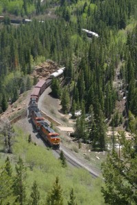
Picture 10) Leaving the siding of Crescent behind, the Ski Train is on the approach to Tunnel 19.
Once you are satisfied with your view of the plains, weave your way back down the side of the mountain to Highway 72. Once there, turn right (west), and follow Highway 72 under the tracks. You will be leaving the tracks behind for awhile, so say your goodbyes in the rear view mirror. You are now in Coal Creek Canyon! Without the same restrictions on grade that trains have, you in your car can plow right up the canyon and over the mountain at Wondervu. One you enter Coal Creek Canyon, it is just under five miles before you have to make your next decision. The name of that decision? Crescent
(Search Siding Gallery)!
When you enter Crescent Village, you will notice a gas station/food market on your left and straight ahead you will see a fire station. The highway curves sharply to the left just before the fire station. Right on the curve there is the opportunity to turn on Crescent Park Drive (the turn is to the right). Decision time! If you want to catch the fifth siding on the Moffat Road, then you need to turn onto Crescent Park Drive. If you wish to continue on to the sixth siding (Cliff), then follow the highway past the fire station. This decision should be made primarily on time. Of the sidings on the east slope of the divide, Crescent
(Search Photo Gallery)
is the one that is the most out of the way. It takes about 10 minutes to get to Crescent from the highway (and thus another 10 minutes back), so you will be away from the highway for no less than 20 minutes (and that is if you simply get there and turn around) if you choose to go to Crescent. (Weather Tip: In the summer, any vehicle can use the roads to Crescent. On bad weather days in the winter, a 4x4 is recommended although generally not required as the roads are frequently travelled. However, it may take as much as double the time to get to and from Crescent on a bad weather day).
Okay, so this information now pertains to those who are taking the time to find your way to Crescent. Crescent Park Drive is something of a
Picture 11) The westbound Ski Train is about to enter the shortest tunnel in the Tunnel District, tunnel 29.
winding road, with a few turnoffs. If you follow the road though, you will come to an intersection with Gross Dam Road, at which point Crescent Park Drive will terminate. You must turn either left or right on Gross Dam Road (the road is unpaved, but kept in good condition). When you reach Gross Dam Road, turn right. You should almost immediately curve to the left and start rapidly descending. Be careful on this road! Some of the curves are sharper then they appear, and it can be easy to go to fast and lose control on the dirt. Gross Dam Road will lead you the entire way to the tracks. You will not see the tracks until you are almost on top of them as the road descends from the mountain side to the grade crossing, which is halfway through the siding itself. The grade crossing has lights and bells, but no gate arms. It is a little bit of a hike from the grade crossing westward, but you can see Gross Dam not too far upgrade. Crescent is located in the middle of the Tunnel District between tunnels 18 and 19. The west end of Crescent immediately leads to a huge fill and not too far beyond (around a curve) is the entrance to tunnel 19.
Once you are satisfied with your pictures from Crescent, it is time to continue west. (Webmaster's Tip: Please do not try to catch the same train at each and every location. You cannot do this safely and safety should always be number one for any railfan.). Drive back up Gross Dam Road until you get to the junction with Crescent Park Drive...however, do not turn on Crescent Park Drive. Continue following Gross Dam Road. It will lead you right back to Highway 72. At the highway, Gross Dam Road merges is such a way that if you are coming off the road onto the highway, if you go straight you will be going west on Highway 72.
For those of you that have been patiently waiting in your cars by the fire station, continue west on Highway 72 and after a mile or so you should notice Gross Dam Road merge in with the Highway. This will be right around the area of Crescent Lake Road and Hummingbird Lane. Now, everyone reading (those who went to Crescent, and those who did not) should be at the same spot! Let's all continue west on Highway 72. Enjoy the drive through the mountains now because you won't be seeing any trains for another five miles.
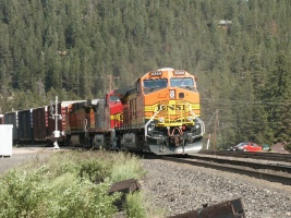
Picture 12) After having just crossed over Highway 72, the westbound MDENSTO is highballing through Cliff on a Saturday afternoon in late June, 2002.
You will travel through the town of Wondervu (where, on a side note, a portion of the movie Switchback - staring Danny Glover and Dennis Quaid - was filmed).
As you are coming down off the mountain (as the distance between curves lessens a little), you will see Black Gulch Road. This will be a road right on the edge of a hairpin, 180 degree curve. Continue on Highway 72, but now keep your eyes peeled for a pull-off on the right side of the road. Often times there will be other cars parked there for hiking and camping. From here, you can hike down to a location above tunnel 29. The land above tunnel 29 is private property, but I have been in contact with the property owner and he is okay with railfans using his land for responsible railfanning. Please do not abuse this priviledge forcing the land owner to restrict all access to this land. You can get some excellent shots around tunnel 29 (see picture 11).
After you are exhausted from hiking, find your way back to your car (drink some water and a few deep breaths) and continue west on - you guessed it - Highway 72. Just a half mile down the road and you will come to a grade crossing at the siding of Cliff
(Search Siding Gallery).
Although trains have not yet passed through tunnel 30 on their journey west, we have now technically left the Tunnel District
Picture 13) Making its way east, the last summer Ski Train of 2002 is in the canyon between Rollins and Cliff.
behind. Through the siding of Cliff
(Search Photo Gallery),
trains are going to pick up a little bit of speed as the curves are not quite so tight. The highway will follow the tracks (and South Boulder Creek) all the way to the west end of the siding. The switch at the west end of Cliff is rather unique in that it is more of a "Y" switch rather than a traditional turnout. Neither the main or the siding is the "non-diverging" track. Both diverge and curve slightly away from one another.
Once you do reach the west end, the highway and the track are again going to diverge, as the tracks follow South Boulder Creek through a narrow canyon, and the highway takes the long way around. If you'd like one more shot from this area, look for South Beaver Creek Road. It is a left-hand turn not far past the west end of the siding. This will lead to a grade crossing with the tracks that makes for a nice shot of eastbounds coming across a bridge running over South Boulder Creek. It is best for morning shots. Don't spend too much time at this grade crossing, however, as there are much better shots to be had further west!
Find your way back to Highway 72 and head west toward Rollinsville. From the intersection at South Beaver Creek Road, you will travel another three miles along Highway 72 before you get to the junction with Highway 119. This is the end of the road (excuse the pun) for Highway 72. Once you reach Highway 119, turn left (south) toward Rollinsville. From here, it is only two miles down Highway 119 to Rollinsville. In Rollinsville (ironically enough) is the siding of Rollins
(Search Siding Gallery).
Rollins is the longest siding between Denver and the Moffat Tunnel, weighing in at 8,320 feet. As you come up on Rollinsville, you will notice that there is a bridge on Highway 119. The road crosses over the tracks at that point. Just prior to the bridge is a right turn onto Rollins Pass Road...can you just imagine where this road will lead you! As you turn off of Highway 119 onto Rollins Pass Road, you will notice that you are parallel to Rollins
(Search Photo Gallery)
as you start your way west on the dirt road. (Weather Tip: Rollins Pass Road between Rollinsville and East Portal is very well maintained and can generally be accessed anytime of year, even without four wheel drive. During the height of a Colorado winter, four wheel drive is recommended, but most other times, you can follow this road in a car).
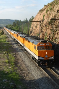
Picture 14) The westbound MDENSTO sits on the siding at Rollins in late April 2004. The train will be holding the siding at Rollins until it can meet with the eastbound Amtrak California Zephyr.
At the west end of Rollins, the road will dive down underneath the tracks, making a sharp 90 degree left turn. The road will also cross over South Boulder Creek. The road will now be on the opposite side of the river from the tracks until just east of Tolland. It is just over five miles from Highway 119 to Tolland. In the canyon between Rollins and Tolland, there are several opportunities for stopping and taking pictures. The land off to the side of the road is public (there are a few spots for camping if you are so inclined). The one downside is that there are generally trees blocking good shots of the tracks as you travel through the canyon. There is one spot in particular, however, just east of the bridge where the tracks cross the river to come back to the same side as the road. If you park on the shoulder, you can hike up the mountain a little way and get a wonderful shot of an eastbound coming across this bridge with the Continental Divide in the background. This shot is definitely best in the morning.
Picture 15) The leaves on the aspens are just about perfect on September 28, 2002 to compliment this eastbound coal load.
Okay, follow the road just a little bit further and you will find yourself entering the "town" of Tolland. (Webmaster's Tip: While you should be responsible and never exceed the speed limit, I urge you to make sure you DO NOT speed within the limits of Tolland. The speed limit through town varies between 15 MPH and 25 MPH (depending on who the current sheriff is). The sheriff lives right off the road in Tolland and can sit on his porch and clock you!). Also running through the town is the siding of Tolland
(Search Siding Gallery),
which is the 8th siding west of Denver. Tolland is not long enough to support most coal trains, but it will often times be used for westbound manifests to meet eastbound trains. The manifest will "hold short" of the grade crossing (this, by the way, sets up a nice photo op in the evening hours) and wait for the eastbound to arrive. The Moffat Tunnel must have the exhaust vented from it after each train, the venting cycle will be complete by the time the westbound reaches the tunnel from Tolland
(Search Photo Gallery).
You will know that you are in the right spot if you see the little yellow school house not far from the tracks. Years ago, this was the school building for the town of Tolland. It has since been boarded up and is no longer used, but it is a marker in that small little village. The Ski Train uses it as a reference point for passengers, letting them know the train is nearing the Moffat Tunnel.
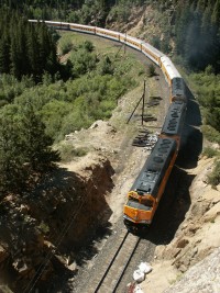
Picture 16) On a beautiful June day in 2003, the westbound MDENSTO is approaching East Portal.
Continuing west past the little yellow school house, the tracks will appear and disappear in the trees to your left. Not too far ahead, you will find yourself crossing underneath the tracks; the bridge for the rails being of classic Rio Grande design. The tracks are running through a classic S-curve (seen from above in Picture 16) just east of East Portal here. Prior to the construction of the Moffat Tunnel in 1923 (completed in 1927), trains would approach the current loaction of the Moffat Tunnel, but take a sharp curve to right (180 degrees) where the current siding of East Portal
(Search Siding Gallery)
is located. The tracks would then start their long climb over the Continental Divide. Once the Moffat Tunnel was completed and the first train successfully went through (on February 28, 1928), 20 miles of the journey (and over 2000 feet of elevation change) were eliminated. The 6.2 mile long tunnel exists today very much the same as it did back then, although with much greater security!
You will cross over the tracks (there will be two of the them; the first being the main and the second being the siding of East Portal
(Search Photo Gallery)
). You then climb a hill, at the top of which gives you an opportunity to follow the current road, or turn to the right and start your way up the grade of Rollins Pass itself. (Weather Tip: Rollins Pass is not plowed in the winter, so shortly after the snow starts falling, you cannot get a car too far up the Pass. Even a 4x4 would have trouble and, in the middle of winter, it will be time to take out the snow shoes, snow mobile, or some other type of snow-equipped vehicle!).
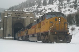
Picture 17) An eastbound coal load emerges from the Moffat Tunnel on a cold, snowy day in early November, 2002.
If you continue west toward the tunnel, you will quickly enter the valley and see the Moffat Tunnel located at the end of it. As you drive toward it, note that you cross a track that is the end of the wye located off of East Portal siding. As you approach the tunnel, you will see an area for public parking. Many people (other than railfans) come up to the tunnel to hike (in the summer) and to snow-shoe and cross-country ski (in the winter). You can no longer drive up to the tracks, or to the mouth of the tunnel. Union Pacific (particularly since 9/11) has greatly increased security of the tunnel. In addition to prevent vehicles from driving up to the mouth of the tunnel, closed circuit monitors (that are watching by Dispatch 82) are used to ensure there is no foul play. Up until the summer of 2005, you will had to cross the tracks near the mouth of the tunnel to get to the trail head. Since then, the trail head has been relocated around and above the tunnel, and even walking to the mouth of the tunnel is strictly prohibited today. As of the winter of 2006, a new camera tower has been erected over the tracks near the east portal of the tunnel. This camera tower is equipped with cameras operated by the Department of Homeland Security, so I do not recommend going anywhere near the tunnel portal anymore.
You will notice that there is a curtain in the tunnel (if there are no trains in the immediate facility). The curtain is striped orange and white and (since the UP/SP merger), a giant UP shield has been added to the curtain. The curtain is a part of the a ventilation system (mentioned earlier in the Tolland section of this guide) used to get all of the exhaust out of the tunnel. When the fans that vent the tunnel turn on, you can hear the sound echoing throughout the valley! At this point, we have proceeded as far west as we can without crossing over the Continental Divide. Which means this is where our journey together must come to a close...at least for this chapter! I'm sure that future chapters are sure to come along.
Hopefully you enjoyed this guided tour of the Front Range of the (former) Denver and Rio Grande Western Railroad. I hope that it will help you in your quest to get some great pictures (or just see some wonderful trains and scenery) and that it helped to enhance your visit to Colorado. To get back to your hotel, just start from the above paragraph and read backwards!
If you have any comments, questions, or suggestions about this guide, by all means email the webmaster!!!