All pictures on this page can be clicked to see a larger (900x600) image.
Please note that the pictures and text on this page will display differently in different browsers, based on your own computer's settings.
If you have any questions, or just a comment about this report, please feel free to Click Here to send a comment to the Webmaster (Kevin). Your comments are always appreciated!
Since 1999, my friend Damian and myself have taken a few days each summer for an annual train chasing trip. Up through 2007, that trip has always concentrated on the former Rio Grande in western Colorado and Utah with emphasis on the Utah Desert and Soldier Summit. Not that there is anything wrong with that, but in 2008, it was time for a bit of a change.
I have been reading about the coal operations in the Powder River Basin for years. Over 150 coal trains moving into and out of the Powder River Basin every day! Millions of tons of coal on the move every single week. There would be one major difference in this trip compared to years past (and not just the location). My wifes job has her working nights often and at 5 1/2 and 2 1/2, our two daughters can't exact watch themselves when they are done with Summer Camp each day! So, the trip would be broken into pieces. The first day, a Sunday, would be an overnight trip up to Wyoming. We would have to return home on Monday in time for me to pick up the kids. Tuesday morning we would leave for the day, returning home Tuesday evening. Wednesday would also follow the same pattern. Perhaps not the ideal situation as we couldn't get as far away from home as we'd like, and we also couldn't stay out all day AND night, but it worked very well regardless. This is our adventure...
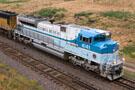
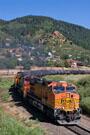
At 2:00pm on Sunday afternoon, Damian showed up in his 1998 S10 to pick me up. The girls were all taken care of for the day and we were free to hit the open road. Hit it we did as we started north of Cheyenne. While we were heading for the Powder River Basin, we happened to luck out and hear that Union Pacific's George HW Bush Presidential Library unit (say that five times fast) was leading an eastbound manifest across the Overland. The timing could be problematic, but it might arrive in Cheyenne prior to nightfall.
|
Once in Cheyenne, we headed west toward Hermosa to see if we could catch up with the train. We made a quick stop off at Borie along Otto Road to grab a shot of a westbound manifest departing Cheyenne. Afternoon storms filled the eastern sky and the contrast of the afternoon sun made for a great shot!
This being our first real attempt to explore the area, there was a bit of risk involved. Not knowing where the train was or exactly where we were doing, the train might slip past us without our knowledge. Sometimes you take risks though, particularly in an effort to get good photos! Unfortunately, much to our dismay, our risk bit us! We found our way to Hermosa just in time to see the Air Force One inspired scheme leading the train away from us!
|
|
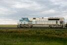
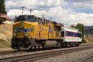
With little other option, we made our way back to I-80 as quickly as possible to head east. It was now getting close to 7:00pm and we figured we should have enough light to do something with UP 4141 closer to Cheyenne. After being bitten by our failed attempt at Hermosa, we decided to play it safe this time and again headed for the overpass along Otto Road at Borie (just west of Cheyenne). Clouds had built up in the western sky now and there was no direct sunlight, but that worked to our advantage. The train came along on Main One and UP 4141 looked very good on the point!
|
We paced the unit west of Borie toward Cheyenne as it slowed (on yellow signals) approaching the west end of the yard. Eventually, it did indeed come to a stop due to traffic ahead. We left the train and headed for the east end of the yard. Our hope being that there might still be enough light after the crew change that we could get a few final shots at the end of the day. We hung around on Norris Viaduct for awhile, but as the light faded, so did our chances of getting any shots.
I thought that it might be time to switch to night mode, so we left our post on the viaduct and got trackside to wait for the train. We setup with tripods and flashes, hoping a night shot might work out. Unfortunately, by the time the train finally reached us, it was simply too dark and the night shots didn't come out. You can't win them all and you can't say we didn't try! With UP 4141 now east of us and in the dark, we pointed our compass to the north and hopped on I-25.
We decided to check out Guernsey, a major crew change point on BNSF in the area. Guernsey is about 15 miles west of I-25 on US-26. We arrived in Guernsey at 9:57pm and filled up the gas tank. Why am I so precise with the time? Because by the time we completed our fill up at 10:01pm, the lights on the outside of the gas station had been turned off. We drove down the road two blocks to a local hotel, only to find the door closed with a sign indicating hotel hours as 7:00am to 10:00pm! So much for Guernsey!
This actually worked out okay as we wanted to be closer to the actual Powder River Basin (BNSF's Orin Subdivision) anyway, so we went back to I-25 and headed north to Douglas, WY. We arrived in Douglas and immediately found a 24-hour Best Western! We checked in and quickly hit the sack, anticipating an early morning. Since I had to be back home in Arvada, CO (230 miles south) and we still wanted to go NORTH to see the action, the alarm was set for 5:30am, just before first light....
(For all the shots from the first day, click here)
The next morning, the alarm went off and we up and out of bed. After some Best Western hotel coffee and some quick freshening up, we checked out and made tracks for Douglas McDonald's. With some hot food in the fuel tanks, we headed for WY-59, the highway that would take us north to the Powder River Basin. Once you hop on WY-59 in downtown Douglas, its just under a 20 mile drive north before you come across the tracks.
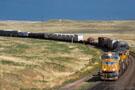
As soon as we saw the tracks, we knew it was going to be a good day! Two coal loads were pacing each other east on the outside tracks (Main One and Main Three) while a coal empty was splicing the two and heading west on Main Two. One thing important to note about the Powder River Basin and BNSF's Orin Subdivision, at least as of this trip. While the tracks run north-south on the map, according to the timetable the subdivision is east-west. Trains running northbound (geographically) are west on the timetable and trains running southbound (geographically) are east on the timetable. Make a note of this for future reference throughout the report!
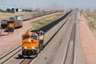
WY-59 comes across the tracks right around MP 102. That is 102 miles south of Donkey Creek Junction at the north end of the line. The line is jointly owned by BNSF and Union Pacific (BNSF actually owning more tracks), and BNSF dispatches the entire Orin Subdivision from Fort Worth. If you are looking to visit the region, the radio frequency you'll want (again, as of this report) is 161.100 (AAR channel 76-76).
|
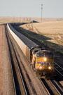
We went a few miles north of where we first came across the tracks, WY-59 running on the east side of the triple track mainline. This was good for us as it was early morning, putting us on the correct side of the tracks for the light. About two miles east (again, by timetable) of the crossovers at MP 95.7, we found a good place to pull over and wait to see what came along. We already knew that we had a westbound coal empty coming up on Main Two, and we figured it probably wouldn't be long before we saw a eastbound coal load too.
|
Indeed, we were correct! As we setup for a shot of the coal empty coming at us on Main Two, clear (intermediate) signals on Main One and Main Three indicated that at least two coal loads would be coming along. One thing we wondered was whether we'd be seeing more UP trains or BNSF trains. I suspect that on balance they are pretty close with BNSF perhaps having a slight edge. However, for the one day we were there, we definitely saw more UP trains.
|
From our perch near MP 96, we watched the coal empty continue north on Main Two and meet a coal load on Main One at the crossovers at MP 95.7. One thing we noticed was that there was a very persistent wind all day long across the Powder River Basin. It was a super strong wind, but enough to make the eyes water from time to time. That effects were very clear a few times as loose coal dust on the top of the hoppers was being blown off a few of the loaded trains.
The temperatures were quite pleasant; not too surprising for being the second week of August. However, I would absolutely recommend planning for any type of weather. In this part of the country, particularly the further north you go, anything is possible! As the wind picked up, there were definitely times when it got a bit chilly and a light jacket would not be a bad idea at all.
A few miles north (on the map) of the crossovers at MP 95.7 and there is a nice overpass that runs over the triple track mainlines. The overpass leads to a storage and maintenance facility for the railroads. We did not drive across the bridge as we did not wish to trespass, but we did park on the shoulder of WY-59 and hike onto the bridge. A few "official" vehicles drove by as we stood on the bridge and we got a friendly wave from each. This bridge is a great place to observe both westbounds and eastbounds, granted the lighting is a bit better for eastbounds.
|
From here, it is a few mile north along WY-59 to the small town of Bill, WY. This is an amazing town in that it basically exists to serve Union Pacific! Bill is a major crew change point on UP. All coal trains that come through Bill get a fresh crew. Now, since UP and BNSF of course have different operations, Bill is nothing more than a name on a map for BNSF. Their trains come straight through. But UP has a yard and engine facility here. On the east side of WY-59, you'll find the Oak Tree Inn and Penny's Diner. The Oak Tree Inn is used as the away terminal for UP crews and Penny's Diner is open 24 hours a day with room service.
|
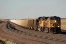
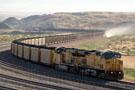
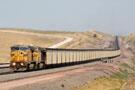
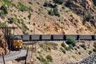
At East Bill (MP 85.5), three main tracks is no longer sufficient for the Powder River Basin. Here, a fourth main track starts! At this point, there are four main tracks for the next 25 miles west. This is the longest stretch of four main tracks (with the exception of passenger service) anywhere in the country. These tracks don't see intermodal service or Amtrak or even manifests. They are devoted to keeping the 150+ daily coal trains moving through the area.
About a mile west of West Bill (MP 80.8) and the tracks cross underneath WY-59 back over to the east side of the highway. This overpass is a fantastic spot for telephoto shots to the west of all four main tracks. In a single frame, you can see about five miles to the north and several signals along the way. From the overpass, we watch as a coal empty headed west on Main Two, a coal load approached us on Main Four, and a clear signal was setup for another empty on Main Three. It truly is a rail super highway!
|
From this point - at the overpass - the tracks and WY-59 diverge. The highway will stay a few miles west of the tracks for the rest of the trip north to Gillette. The tracks head (timetable) west to challenge Logan Hill and reach some of the southern mines on the Powder River Basin. These mines include Antelope Mine, North Antelope Mine and Rochelle Mine. If you continue north on WY-59 for 10 miles, you'll come across Antelope Coalmine Road (also County Road 37).
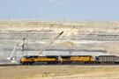
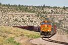
We found this road and took a right figuring it would take us to the tracks. And indeed it did lead us very close to Converse Junction, the first junction between the main tracks and the mines. The first mine as you headed west on the timetable is the Antelope Mine. This mine is on the west side of the tracks and the lead to the mine branches off from Main Four. The mine itself has five leads. Two are inbound only, two are outbound only, and the fifth track up the middle can be used for inbound or outbound.
We stopped for awhile at Converse to observe the action. A UP coal load was coming through a long S-Curve on Main One. The train had just loaded at North Antelope Mine, the next mine to the north. Meanwhile, at Antelope Mine, a BNSF coal train was departing on Main Four heading east having just completed loading. At the same time, a UP coal empty was starting to move into the mine and under the tipple to begin loading.
|
After spending some time at Converse, we hit the road again continuing further north. It was around 10:30am at this point and we were keeping a very close eye on our mileage and time. We had to be back in Arvada in seven hours! We kept moving north on County Roads, finally reaching Reno Junction. This is a little over halfway north along the Orin Sub and the location where the next major set of mines lay. These mines include Black Thunder Mine and Jacobs Ranch Mine.
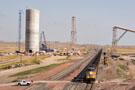
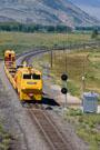
A new tipple is being built along the tracks at Reno Junction, a conveyor belt also being erected to move coal to the tipple. A huge crane being used to move a conveyor tube over the tracks collapsed back in May 2008. Fortunately, nobody was killed, but all three main tracks were blocked until everything could be cleaned up. When we were there on Monday, the conveyor belt has yet to be completed.
|
Reno Junction was as far north as we decided to go as it was a long trek back home to Colorado and we wanted the option to stop and take pictures along the way. We headed back toward the Antelope Mine as I had a shot in mind that I noted earlier in the day. The mining operations in the Powder River Basin are amazing to see. The amount of earth that has been moved to reach the coal seams is almost unbelievable. It almost looks like mini Grand Canyons running through the Wyoming landscape.
One of the cools things about the mining operations is that they actually have a relatively low impact on the environment in the long run. After coal has been exhausted from an area, the dirt is replaced and everything continues as it did before mining started. Anyway, from the shoulder of Antelope Coalmine Road there is a nice backdrop to the west of the tracks and the mining operation for the Antelope Mine. We stopped and got a shot of a coal load passing in the foreground in front of one of the cranes being used to extract coal.
|
By the time we made it back to Converse Junction, the UP coal train that had just started its loading operation when left earlier had been completely loaded and was getting ready to depart and head east. At the same time, a coal load from further west up the line was making its way south on Main Four on a clear signal.
On our way back south to Bill, we were getting hungry as it was close to lunch time. Since Penny's diner is indeed open to the public (in addition to all the room service calls they get for UP crews!), we stopped on in to sample out the food. We both gave it two thumbs up. The staff was very friendly and very clean. Breakfast, lunch and dinner items are all available 24/7. Damian sampled the Philly Cheese Steak and I had Penny's classic burger.
|
|
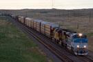
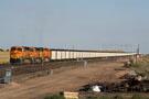
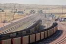
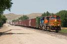
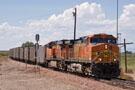
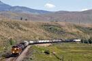
After our stop for food, we hit the highway again and continued south on the way out of the Powder River Basin. A BNSF coal train was just passing through Bill at the same time and we paced it south a ways, back to the maintenance facility near MP 90. There aren't a ton of places in Colorado where you can shoot an entire 7,000 foot long coal train in a single frame. It is much easier to do in Wyoming!!
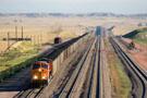
We continued south to the first place we had stopped earlier that morning near the crossovers at MP 95.7. We had caught up to another eastbound coal load here and we were wondering if the BNSF coal load we had been pacing was going to try to catch and overtake the UP train. That didn't happen though as the UP train appeared to be making the same speed as the BNSF train. The BNSF train did give some chase though as it appear on the horizon as the UP coal train approached and passed our location.
|
From here we continued south the last few miles before WY-59 and the Orin Subdivision part ways. From here, trains continue southeast to Shawnee Junction. There, UP trains turn east on enter UP-owned tracks. BNSF trains turn southwest and run on BNSF-owned tracks. Once back in Douglas, we got back on I-25 and started heading south. At Orin, the highway intersects with the BNSF tracks again. BNSF's Casper Subdivision, which comes down from northern Wyoming and Laurel, MT join with the tracks from the Powder River Basin at Bridger Junction.
|
All trains coming from Laurel as well as all coal trains coming from the Powder River Basin come to Bridger Junction and use the Canyon Subdivision to the south to get where they are going. While the Orin Subdivision has three and four main tracks, the Canyon Sub is largely a single track mainline. However, we did discover that BNSF is in the process of grading the northern end of the Canyon Sub, getting ready to put in several miles of two main track territory. At least three new bridges have already been built.
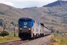
At Bridger Junction, we happened to see BNSF's daily Laurel, MT to Denver, CO freight (the HLAUDEN). This was somewhat interesting as this is a train that I shoot on a fairly regular basis a few hundred miles to the south! It was interesting seeing it in a different territory. The train was leaving the Casper Subdivision behind for the thirty mile journey down the Canyon Subdivision to Wendover. At Wendover, the Front Range Subdivision starts, diverging from the Canyon Sub. Once there, the train would continue on its journey to Denver.
A shot of the HLAUDEN just north of Glendo, WY would be the last shots of the day. At this point it was just after 2:00pm and time to head back home. We got back to Arvada at 5:10pm, giving me just enough time to get to my daughters Summer Camp and pick them up. It was a wonderful first dive into the Powder River Basin!
(For all the shots from the second day, click here)
After dropping my daughters off again at Summer Camp Tuesday morning, Damian showed up and we had to decide where we were going to go for the nine hours we had free. We decided since we had gone north the day before, it was time to go south. Monday we followed the UP/BNSF Joint Line in Wyoming (the Orin Sub) and Tuesday it was time to hit the Colorado Joint Line between Denver and Pueblo.
|
When all was said and done, Tuesday was definitely our slowest day. When we left Denver, there was nothing at the north end of the Joint Line heading south. In fact, we didn't see a single southbound until we made it to Spruce, just north of Palmer Lake. As we approached the top of the hill (Palmer Lake), we saw a coal load coming up behind a BNSF manifest. The manifest, which we later found out was BNSF's daily Denver to Kansas City freight (the HDENKCK), was stopped on Main One. We went around to the south side of Palmer Lake and setup for the classic shot of the manifest coming around the south side of the lake. We didn't have to wait long and the train didn't disappoint!
From Palmer Lake, we skipped over the single track main along Monument and Academy and headed into Colorado Springs. We thought we might see UP's yard job working and we might be able to give some chase. The power was indeed moving in the yard when we arrived, and we hung around to see where it was going. Unfortunately, not ten minutes after we arrived, the crew took the train to the depot and tied it down! So much for that plan...
By now it was already getting to be lunch time. We continued south out of the Springs toward Fountain to see if we might come across something else. Oh, one thing that is worth noting here. My scanner broke Tuesday morning, leaving us without any ears for the day! We couldn't hear track warrants being issued or the location of any trains. The scanner itself was okay, but the wire going to the antenna literally broke in two!
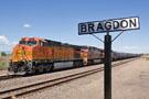
Without finding anything to chase in Fountain, we stopped to grab some lunch. We ate at a Kentucky Fried Chicken that was right along the tracks near Crews, where the double track starts again south to Bragdon. We enjoyed lunch and finished up right around the time our Denver to Kansas City freight caught back up to us.
|
The tracks between Crews and Bragdon follow I-25 the whole way, and it is something we refer to as Interstate Chasing. It is a bit of a pain because you can't pull off to the shoulder (at least, we don't attempt it) to grab shots. We stuck on I-25 all the way down to exit 108. There, you can drive over to Bragdon, the southern end of the Joint Line. North of Bragdon, northbound trains operate on UP's track (Main Two) and southbound trains operate on BNSF's track (Main One). At Bragdon, all BNSF trains operate on BNSF tracks (the western track) and all UP trains operate on UP tracks (the eastern track), regardless of their direction.
After our manifest passed us at Bragdon, we continued south in Pueblo to take a look around at the yards. Without a scanner, we were worried about things we might be missing, but did the best we could. The coal load that we had seen at Palmer Lake behind the Denver to Kansas City manifest apparently made good time south, running on the hills of the HDENKCK. Not long after we arrived trackside at Pueblo Junction, the coal load approached from BNSF's Yard.
With nothing else in the area...and some maintenance of way hanging nearby...we decided to follow the coal load. The maintenance of way was no doubt waiting to get on the tracks which would definitely mean no more trains!
For those of you not familiar with operations south of Pueblo, BNSF has directional running between Pueblo, CO and Dalhart, TX for its trains. Train will depart Pueblo southeast on the Pueblo Subdivision (former ATSF tracks). The Pueblo Sub is CTC from Pueblo to NA Junction. From there, it is track warrants and ABS to La Junta. From La Junta, trains take the Boise City Sub south into Oklahoma and then on to Dalhart.
|
Trains returning north from Texas will take the Twin Peaks Sub from Dalhart, TX northwest to Trinidad (about 80 miles west of La Junta). Northbounds then use the Spanish Peaks Sub north from Trinidad to Pueblo. With our southbound on the the roll, we left Pueblo on US-50 and headed for Baxter. It didn't take long for the train to reach us as it was making good track speed. We got ahead of it along US-50 and then took CO-96 along the tracks from Avondale to NA Junction.
|
NA Junction is the location where the former Missouri Pacific line merged with ATSF tracks for the journey (on ATSF tracks) into Pueblo. When the Missouri Pacific and the Union Pacific mergered, the Rio Grande (still in existence at the time, of course) actually gained trackage rights on the Missouri Pacific from NA Junction east to Kansas City. Had things worked out a bit different with Tennessee Pass (meaning if UP hadn't mothballed the line!), coal train might still be running on the MoPac from NA Junction into Kansas.
Instead, as we all know, UP deserted Tennessee Pass and the MoPac and instead invested in the KP line east of Denver. And interesting observation is that the KP line runs southeast as it leaves Denver and the MoPac runs northeast as it leaves NA Junction. At their closest point, the two lines are only about twenty miles apart. Imagine if UP had connected the two lines, allowing for directional running over the MoPac, Tennessee Pass, the Moffat and the KP!
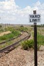
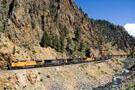
As far as I know, UP sold off the MoPac to short line railroads, although I don't know exactly which ones or how often the line is operated. There was a derail protecting the MoPac at NA Junction and the tracks didn't look that out of shape, but I'm just not certain. This last picture from day three (to the right) shows the MoPac as it departs east from NA Junction. There aren't that many weeds in the right of way and the rails have a relatively small amount of rust on them.
After watching our coal load pass NA Junction, it was once again time to call it a day. It was now just after 2:00pm and we had a long drive to get back to Denver. We got on US-50 and went straight back to Pueblo, then taking I-25 back north without any stops. At least, until we got to Castle Rock. There, it was time for fuel. It was also now just after 4:30pm. Less than an hour to make it to Arvada. That is a tall order! The distance isn't all that far, but traffic is pretty rough on the south side of Denver, particularly at rush hour.
Rather than trying to challenge Denver's "Tech Center" along I-25, we took US-85 along the tracks north to Littleton, and then took C-470 along the southwest side of the city up to I-70. It was something of a crap shoot, but we got lucky! I got to the doors of Summer Camp right at 5:30pm! The third day was in the books.
(For all the shots from the third day, click here)
This of course brings us to the fourth and final day of our Summer 2008 adventure. We had talked about hanging around the Denver area for our final day, but when Damian picked me up, he really wanted to leave Denver in one final direction...the west! I certainly wasn't going to argue as it had been awhile since I'd been to the western slopes of the former Rio Grande.
We got to Winter Park on US-40 shortly after 9:00am and started looking for trains. Neither of us had shot in Fraser Canyon before (between Tabernash and Granby) and so we started our day trying to find a way to access the canyon without excessive hiking. Fortunately, Damian was able to effect repairs to the broken antenna wire from the day before, so we had our "ears" back for the day.
|
After some searching for access into the canyon, we didn't find anything that worked out as well as we'd like, but we do have some ideas for the future! At one point while we were searching, we heard some maintenance call UP's Dispatcher 82 to request an hour of track and time. We were very pleased to hear the response..."well, I don't see when that is going to happen as we have nine trains coming up the hill out of Denver toward you." It looked like it was shaping up to be a pretty good day!
|
Because we had so many westbounds, we decided to head west ahead of the trains and then slowly move east, shooting the fleet of westbounds at various locations as we saw fit. We went as far west as Troublesome where we heard our first westbound, BNSF's Denver to Stockton manifest, would be taking the siding. As it turns out, the train took the siding to meet with some maintenance equipment heading east.
What maintenance equipment? It actually turned out to be a Herzog train. These mini trains move around on track and time and are typically used to clean up the railroad a bit. In this case, the Herzog was picking up used ties along the railroad right of way. The Herzog received track and time to proceed east to Flat. Once there, the maintenance train tied down on the house track and wrapped it up for the day.
|
Meanwhile, the BNSF train continued to Kremmling where it received a crew change. Damian and I started our trek back to the east in search of additional westbounds. As it turned out, the westbound California Zephyr was the next thing coming toward us. We setup for a shot just west of Byers Canyon not too far east of the town of Parshall, CO.
|
|
It was wonderful having our scanner back at this point so we could get an idea for what was coming next. UP's Dispatcher 82 indicated that a Drake coal empty and a light power move was next up on the list. The coal empty was already out of Sulphur, so we found a spot near the west end of Byers Canyon to get a few shots. I always enjoy shooting trains in Byers Canyon. It is amazing how tight the curves are through the canyon and it just another example of the amazing engineering the went into the construction of the line.
With the coal empty now west of us, we repositioned at the east end of Byers Canyon and waited for the light power move. Shortly after noon, the nine units came west out of Sulphur and entered into the canyon. The units were headed for Grand Junction (or, more likely, Glenwood Springs), where they will be used as mid-train swing helpers on eastbound coal loads.
We stopped to get gas in Hot Sulphur Springs and grabbed a couple of sandwiches before heading further east. This is where we heard some news on the scanner that could be a bit negative. The next westbound was actually a track geometry car. It was, in fact, the FRA's track geometry car, DOTX 220. So why was this considered negative? Because the track geometry car was apparently doing its job quite well! The cars had been slowly moving back and forth over track in Fraser Canyon. It had already found four defects (each requiring a slow order) and it wasn't clear how long before teh train would reach Granby.
|
We went ahead and stopped near the west end of Granby and waited patiently for close to two hours for the geometry car to show up. Finally, right around 2:00pm, the car (led by a year-old ES44DC) came clipping by at track speed, headed for Sulphur. We heard from the scanner that the next westbound was already leaving Tabernash, so there was no point in leaving Granby. Of course, thanks to the slow orders the geometry car had just dumped in Fraser Canyon, we knew we had another wait ahead of us!
|
Indeed, it was another 45 minutes before the coal empty finally showed up in Granby heading west. With the coal empty now past, we hopped back in the car and proceeded east to Tabernash. There, we thought we could setup for a shot of the next westbound coming across the valley between Fraser and Tabernash. Unfortunately, we struck out in this pursuit. We had to leave the truck in order to setup for our shot, but the scanner was isolated to the truck due to the external antenna it was using.
We waited at Tabernash for an hour, wondering why the next westbound hadn't shown up. Had we had access to the scanner, we would have heard that the next westbound, the MNYRO, had gone into emergency just east of Fraser and the conductor was walking the train. Well, that was it! It was now 3:45pm and time to head back to town once again to pickup the kids by 5:30pm. Sometimes you get the train and sometimes the train gets you!
I'm not complaining though, even with the rather slow afternoon that we had. We still had a great four days and covered LOTS of ground, much of it new to both of us. We got back to town just after 5:00pm and I got the girls. From there, it was back home where I started the process of formatting and posting pictures, right here on ColoradoRailfan.com for your viewing pleasure!
(For all the shots from the fourth and final day, click here)
I hope you enjoyed this lengthy report and the pictures included therein. If you have any questions, or just a comment about this report, please feel free to Click Here to send a comment to the Webmaster (Kevin). Your comments are always appreciated!
|
|
Check out ColoradoRailfan.com on Facebook |
|
|
Check out the latest ColoradoRailfan.com photos on Flickr |
|
|
|
||||||